A Praxeological Analysis of Augmented Reality Navigation in the Early Twentieth Century
Tristan Thielmann
1. Introduction
Although augmented reality navigation appears at first glance to be something completely new, it is in fact based on a very old cultural technique. Virtual travel through pre-recorded spaces can be traced back at least to 1905, which saw the first attempt at capturing the residential streets of select routes in photographs. The idea was to make them available as ‘photo-auto guides,’ with superimposed textual and pictographic route instructions. Moreover, these guides were designed as ‘social media,’ with empty lines under each photograph allowing the preservation of photo-related memories. The navigation instructions were layered within a series of photographs, as if arrows had been drawn in the dust of the streets. Therefore, while ‘texting and driving’ with photo-auto guides, the viewer is in a first-person navigational experience. This permits the viewer to wander through the depicted space, moving deeper into the frame and exploring off-screen space.
This paper presents a material analysis of linked location-based photographs by looking at their mode of navigational practice and form of production. In doing so, we follow the recursive trajectory of photo-auto guides, which had their heyday between 1905 and 1912 (Ristow 1964, p. 622).
2. Theoretical grid position
2.1 Performative cartography and operative images
Photo-auto guides can be characterised by their integration of very different media: the interplay between landscape photography, textual instructions, road maps, and inscribed direction signs, combined and unified through the medium of a book (see Figure 1).

Figure 1. The Rand McNally Photo-Auto Guide Chicago to Lake Geneva (1909) as an open book; photos no. 19 to 22 of the paragraph „Return from Lake Geneva to Chicago.“
The operability of this medium is therefore characterised by a hybrid of 4 already established navigational practices: a) virtual travel by pinpointing on landscape photographs; b) following verbal logs of routes; c) following a diagrammatic map of a route with the eyes or a finger; and d) inking lines that trace the route of an automobile journey on a white sheet or printed map.
This inscribed complexity may be one of the reasons for the fact that photo-auto guides have yet to be the subject of an in-depth analysis, either in the field of cartography, in science and technology studies, or in media studies. Photo-auto guides have led a rather more marginal existence as „boundary objects“ (Star, 1989). Another barrier to the study of route guides is the traditional propensity of cartographic theory, media theory and historiography, to focus on the end-products of the mapping process – and therefore on an understanding of route sketches as artifactual maps – rather than on the process as a practice in itself.
However, according to Rundstrom (1991, p. 6) it can be argued that any kind of map is a trace of an ongoing accomplishment that „situates the map artifact within the mapmaking process,“ and at the same time „places the entire mapmaking process within the context of intracultural and intercultural dialogues occurring over a much longer span of time.“ This implies two consequences: From a praxeological perspective, the study of cartographic and navigational practices is constantly blurring the distinction traditionally made between map makers and map users, whilst taking into account their different skills, knowledge and agency. From a genealogical perspective and by referring to WJT Mitchell, this leads to the argument that maps are inevitably „redirected to the history and anthropology of the image“ (Harley 1989, p. 8).
In the course of this discussion, Christian Jacob’s influential call for an extensive study of the culture of map use (Jacob 1996) has reached the field of media studies, as demonstrated in processive concepts such as „performative cartography“ (Verhoeff 2012) or „operative images“ (Krämer 2009).
According to Krämer, operative images are situated in the intermediate field between map, notation and diagram. They can be characterised by a) their flatness (a two-dimensional spatial layout and order that cause synoptic concurrence); b) their directionality; c) their graphism (particularly lines that draw a distinction); d) their syntacticality (whereby images are not only viewed, but have to be read); and e) their referentiality (with respect to exteriority). All these characteristics can be applied to the operative photos discussed here.
The object of this investigation is photography that is turned into layered operative imagery through inscriptions (see also Lehmuskallio in this book). These „graven images“ (Mukerji 1983; Latour 1990, p. 34) are operative in two ways: On the one hand, the presented photographs have been subjected to operative changes through information being embedded in their surface; on the other hand, the photographs were taken and compiled in such a way that they became part of an operative practice: the practice of autonavigation.
One component in the practice of autonavigation is following the traces of route sketches, which the photo-auto guides discussed here include in an enclosed book section. Mappings of this kind of have a difficult status in cartography, as they are located on the border between printed and therefore timeless maps on the one hand, and ephemeral manuscript maps on the other.
American road mapping is a perfect example of this kind of boundary work. It reveals a number of examples that lie on the cusp between unfinished intermediary cartography and the endpoint of a mediation process: a finished spatial representation. These boundary objects include the wide range of route guides that were published in the USA at the start of the twentieth century (Akerman 2006).
During the 1900s, route logs were published by motor clubs and a host of semipublic and private organisations. In some cases, these collections of logs were accompanied by simple diagrammatic maps of the routes they described. The standard work of this kind was published by the Automobile Blue Book Company; its first volume came out in 1901. In 1906, the Automobile Blue Book gained the endorsement of the American Automobile Association (Ristow 1946, p. 400). These guides provided hundreds of detailed mile-by-mile verbal logs of recommended routes for travel between major cities. The photo-auto guides discussed here also belong to this category of published itineraries of intercity routes.
The log collections reached the end of the road, so to speak, as soon as travel bureaus began offering customised route plans and American oil companies distributed free road maps (Akerman 2000, p. 35). Hand-inked lines tracing a proposed route on printed sheet-maps were superior to augmented reality navigation, as they could be further personalised and were more flexible to use.
Akerman reveals the different roles and functions fulfilled by the inscribed road maps. Above all, they served as records of past routes, revealing „the traveler’s pride in these trips and their affection for their memory“ (Akerman 2000, p. 32). It is no surprise that the photo-auto guides took this route-logging function into account and contained a memo field for personal entries.
In addition, it was not unusual at the start of the twentieth century for institutional inscribers, as well as individual inscribers, to be involved in the map-making process. The photographs inscribed with arrows in the route guides discussed here can also be understood as such pre-consumer annotations, revealing the intermediary and ephemeral status of the routes they set forth.
2.2 Mediation Theory
The actor-network theory (Latour 2005) included a mediation theory developed by Bruno Latour (Thielmann and Schüttpelz 2013) that can be used as a basis for the analysis of navigation practices with the aid of photo-auto guides.
In his studies in navigation and the sociology of technology, Bruno Latour traces the linking of people, artifacts and signs via mediators, delineating the logistics that make changes of scale possible (e.g. November et al. 2010). Seen from a media studies perspective, this enables the formation of a praxeological media genealogy founded on the concept of mediation by drawing on the analysis of chains of media translations, as well as on the tracing of cumulative technological developments.
In the studies of science and technology, this chain of operation follows a deflation strategy that always leads to „a small window through which one could read a very few signs from a rather poor repertoire“ (Latour 1990, p. 22). These inscriptions, as he calls them, „have the properties of being mobile but also immutable, presentable, readable and combinable with one another“ (Latour 1990, p. 26). The more artificial and abstract the inscriptions, the greater their capacity to be associated with others and thus to approach reality more closely. The degree of similarity also serves as an index in a chain of association, which leads, seemingly unavoidably, to standardisation and institutionalisation within „centres of calculation“ (Latour 1987, p. 215ff.).
In his book Science in Action, Latour illustrates the accumulation of knowledge within centres of calculation by an analysis of knowledge gained through mapping and surveying – explaining how implicit local knowledge becomes the universal knowledge of cartography. In order to accumulate knowledge within centres of calculation „you have to go and to come back with the ‚things‘ if your moves are not to be wasted. But the ‚things‘ have to be able to withstand the return trip without withering away“ (Latour 1990, p. 26). With regard to photography, this means: „What should be brought into the picture is how the picture is brought back“ (Latour 1990, p. 25).
The central image-theoretical assumption is not to understand inscriptions as isolated references. Operative images are situated at the beginning, in-between, or at the very end of a long series of transformations (Latour 2014). Location-based photography therefore has to be interpreted in contrast to the punctured trace, the course (of action) from which they are taken. In other words, performative cartography or operative geoimages are never only mimetic. If they were, no wayfinding process would be possible (November et al. 2010).
The fact that we are dealing with „migrating images“ that arrive and depart (Mitchell 2004), very much within the sense of picture theory, is revealed in a highly specific manner based on the inscribed photographs that are listed in the photo-auto guides published by Rand McNally.
3. Analysis of photo-auto guides between 1905 and 1909
3.1 Groundwork
At the start of the twentieth century, Rand McNally & Company was one of the first automobile road map publishers (Ristow 1964, p. 622) and therefore also a centre of calculation, very much in the sense of Latour’s use of the term. The company had made its name in the nineteenth century mainly by printing timetables and guides for railroads. Based on the experience of printing the Railroad Guide, which was a route map for a single railroad, the son of the company founder, Andrew McNally, apparently had the idea of producing corresponding route maps for automobiles (Santi, 1998). These were route guides leading to and from Chicago, site of the company’s headquarters. H. Sargent Michaels produced the first „Photographic Automobile Maps,“ from which the name of these guides originates, in 1905. The Newberry Library archive in Chicago has the Rand McNally & Company records for the years from 1856 to 1996 and stores an entire series of these „photographic runs,“ as the photo-guides were also called.
According to a Rand McNally advertisement, there were 27 different „Photo-Auto Guides for Motorists“ in 1909. Of these guides, 7 guides will be the object of analysis below:

Photo-Auto Guides for Motorists
• The Rand McNally Photo-Auto Guide Chicago to Milwaukee – Milwaukee to Chicago (Kilbourn Route). Chicago/New York: Rand McNally 1909 (© H. Sargent Michaels 1905). [C-M/M-C 1909]
• The Rand McNally Photo-Auto Guide Chicago to Lake Geneva – Lake Geneva to Delavan – Delavan to Beloit. Returning from Lake Geneva, via Channel Lake, Lake Catherine, Lake Marie, Antioch, Loon Lake, Cedar Lake, Deep Lake, Lake Villa, Grays Lake, Libertyville, Half Day, and Highland Park. Chicago/New York: Rand McNally 1909 (© H. Sargent Michaels 1905). [C-LG/LG-C 1909]
• The Rand McNally Photo-Auto Guide Chicago to Cleveland – Cleveland to Chicago. Chicago/New York: Rand McNally 1909 (© G. S. Chapin 1907). [C-C/C-C 1907]
• Photo-Auto Maps New York to Chicago – Albany to Saratoga Springs, Saratoga Springs to Albany – Toledo to Detroit, Detroit to Toledo – South Bend to Indianapolis, Indianapolis to South Bend. Chicago/New York: Rand McNally 1907 (© G. S. Chapin 1907). [NY-C 1907]
• Photo-Auto Maps Chicago to New York, New York to Chicago – South Bend to Indianapolis, Indianapolis to South Bend – Toledo to Detroit, Detroit to Toledo –Albany to Saratoga Springs, Saratoga Springs to Albany. Chicago/New York: Rand McNally 1907 (© G. S. Chapin 1907). [C-NY/NY-C 1907]
• Photographic Automobile Map Chicago to Lake Geneva – Lake Geneva to Delavan – Delavan to Beloit. Returning from Lake Geneva, via Channel Lake, Lake Catherine, Lake Marie, Antioch, Loon Lake, Cedar Lake, Deep Lake, Lake Villa, Grays Lake, Libertyville, Half Day and Highland Park. Chicago, Ill.: H. Sargent Michaels 1905. [C-LG/LG-C 1905]
• Photographic Automobile Map Chicago to Milwaukee. Also Intermediate Points Highland Park, Waukegan, Kenosha, Racine. Chicago, Ill.: H. Sargent Michaels 1905. [C-M 1905]
Methodologically, we will approach the observation of the photo-auto guides in reverse order, both at the historiographic and praxeological levels, in order to find inscriptions that are „able to withstand the return trip,“ as Latour (1990, p. 26) describes it.
In the following, we are attempting to make visible the recursive chains of operation. This is because, in particular, the historical reverse observation of the photographs of the return journey reveals which portions of route information are of relevance in navigational practice – which objects „have the properties of being mobile but also immutable, presentable, readable and combinable with one another“ (ibid.).
3.2 Case and comparative analysis
The 27 photo-auto guides published by Rand McNally were mainly new editions of H. Sargent Michaels copyrighted versions from 1905. This also applies to the first two examples discussed here: [C-M/M-C 1909] and [C-LG/LG-C 1909].
Trace 1
The preface to the Rand McNally Photo-Auto Guide Chicago to Milwaukee – Milwaukee to Chicago [C-M/M-C 1909] states that there are at least six different routes that can be taken to get to Milwaukee:
The selection herein made is the best possible route. The ‚Shore,‘ ‚Green Bay,‘ ‚Howell,‘ ‚New,‘ ‚Loomis,‘ and ‚New Chicago‘ are all good in places under favorable weather conditions. The one selected is not a macadamized boulevard, by any means; it has its good and bad spots the same as all the others, though the bad ones are not as numerous as in following any single one of the above-named routes. After heavy rains the one given recovers more quickly than the others. Also one of the principal reasons for selecting the entire route as photographed was that the people and horses are more familiar with automobiles, reducing that source of danger and delay, and as a rule, favors are readily granted. [C-M/M-C 1909]
The decisive criteria for the choice of route are given as enjoyment of the drive, road condition, shortness of the route and the lowest possible danger due to railroad and streetcar crossings. The selection of the route is not made for technical reasons alone, but is also based on social reasons: The authors assumed that automobiles would be better tolerated on the Kilbourn Road route than on the others. Assumptions about the expected density of traffic are clearly already integrated into the production of these guides. The maps and the photographic series arranged in them are therefore not cases of a pure representation of a physical infrastructure, but are already socio-technical representations.
The photo-auto guide comprises 26 photos for the journey to Milwaukee and 23 photos for the journey back to Chicago (98.8 miles each). The return journey features fewer pictures. It is evidently assumed that the users have already travelled along the route – that the photographed and practically experienced return journey are congruent.
This photo-auto guide, with its 49 photos, is thus one of the less comprehensive route guides in the Rand McNally series, and this is reflected in the price. In contrast to the $5 photo-auto guide from Chicago to New York, the Chicago-Milwaukee guide cost only $1.25.
All photo-auto guides are structured in more or less the same way. The front section features a photographic run of the outbound journey, with a numbered photographic run in the back section for the return journey. The numbered photographs correspond to the numbers on 7 ‚outline maps‘ that are found in the middle of the guide.
In all of the photo-auto guides, the route starts and ends at a hotel. The photographs of the forks in the road for the return journey are essentially the same, but are taken from a different perspective.
In this special guide version [C-M/M-C 1909], the inscribed arrows fit into the background landscape, as the arrows were drawn on the photographs as if they were directional instructions that were visible in geographical space. The arrows and the names of destinations that are occasionally inscribed are integrated into the landscape in perspective.
The photos were taken either at eye-level or from above to allow for inscribing the arrows as centrally as possible and with the least possible distortion in perspective. The roads are generally empty in this edition, with neither people nor other vehicles. Clearly, the photographer was working towards creating a space that was as open and uniform as possible for the inscriptions.
Bridges, canals, rivers, viaducts, railroad and streetcar lines, as well as forks in the route, are entered into the route sketches. The route sketches only show what is visible when the driver is on the route (see Figure 2). They show nothing else. This means that the route sketches simply duplicate the information that can also be gleaned from the photos and the figure legends.
Even if no scale is given in the route sketches, the pictures still attempt to convey the different distances between the locations where the photos were taken. However, this uniformity of scale only refers to the individual sketch on each single page of the guide. The map scale is reduced when longer distances are covered between cities, so that the route can be depicted. Drivers may therefore switch to a new scale when turning the page.
Some pages show two or three segments of the route in parallel, though they are to be followed one after the other. The individual pages can therefore not be read as an imaginary stringing together of a route, as was common in military cartography in the nineteenth century, when reconnaissance led to the depiction of the visual history of a campaign (Engberg-Pedersen 2011, p. 40ff.). The spatial fragments of campaigns that also develop a narrative differ from the route maps discussed here in that they are aimed at visualising the terrain and are constrained by an absolute spatial construction.
In the event that there is no change in direction, the illustrated route is compressed. The medial translation thus develops its own spatial temporality. The basis for the visual depiction is the travel time that has been completed. Route elements in the city that are covered at lower speed are illustrated in more detail; only rough sketches are provided for cross-country routes that are covered at greater speed. The illustration of the route thus uses a relational scale and not an absolute scale.
On the outbound journey, the route sketches are read from the bottom upwards. The medium is thus tailored toward being read in the direction of travel. On the return journey, the same route sketches are followed in the opposite direction, from top to bottom. The practical use on the return journey is thus hampered by substantial difficulties, as the maps must be read opposite to the direction of travel.
Trace 2
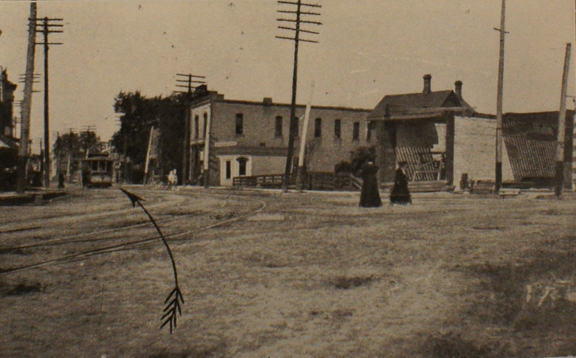
The Photo-Auto Guide Chicago to Lake Geneva – Lake Geneva to Delavan – Delavan to Beloit. Returning from Lake Geneva [C-LG/LG-C 1909] is also a new edition of the H. Sargent Michaels copyrighted version from 1905. It contains 38 photos for the route from the Stratford Hotel in Chicago to the Hotel Denison in Lake Geneva (84.1 miles) and 10 photos for the route from Lake Geneva to Beloit (35.1 or 35.3 miles). The return journey from Lake Geneva to Chicago (82.9 miles) is depicted in far less detail than the outbound journey, with 22 inscribed photos. The 29.2-mile stretch from image no. 22 (Central Ave) back to the Stratford Hotel does not have a single additional photograph. This demonstrates that this photo-auto guide was designed for daytrips „that can be made in one day, up and back“ (from the preface). Prior knowledge of the route based on the outbound journey is a precondition.
In addition, the route instructions for the entire route, including all changes in direction, are summarised on one page in continuous text. Furthermore, this photo-auto guide provides an overview of all photos, giving details on the distance that remains to be covered after the photo has been passed. The previous guide gives the total accumulated route underneath the photos. That is missing here. Instead, there are 4 maps at the end of the guide that show the roads along the numbered plots of land that are grouped around the lakes. What this reveals is that roads in many parts of the country followed the line fences of farms and were located, as a general rule, for the benefit of the property owner, not for the benefit of the travelling public (Dods 1911, p. 3). It is a reminder that road traffic was never regarded as a national responsibility in the US, but was managed by the counties and cities (Reid 2014, p. 151f.)
Comparative analysis of Traces 1 and 2
It is notable that the first 9.6 miles of the photo-auto guide from Chicago to Milwaukee and the guide to Lake Geneva are essentially identical. Some of the inscribed photographs are therefore found in both guides.
Even though the initial stretch ought to be identical, the route that is given is slightly different. This reveals a navigation problem that is typical for US conditions: Cities are planned in quadrats, such that one is always moving along either a North-South or East-West axis and can never lose one’s sense of direction. Accordingly, the cardinal directions play a central role in the photo-auto guides. Typical instructions on the photos read „To Left, West“ or „To Right, North“. The cardinal directions are also important because the photo-auto guides did not use a uniform pictorial language that would always show the subjective perspective of the motorist. They do attempt to ensure that the driver and camera perspectives are identical, but this principle is not maintained in every photo.
On the return journey, there is a series of photos (nos. 6-8, 13-21; photos 9 to 12 are missing from the copy) in which the same automobile is depicted with the same driver. The automobile is always in exactly those places that show which route must be selected. Apparently, the photograph was composed such that the decision on which direction to take is visualised through imagery. The arrows thus simply emphasise the information conveyed by the image, which could also be gleaned from the unaugmented photograph.
However, conceptual flaws resulting in heterogeneous imagery crept in and must have caused confusion in navigational practice. The flaws stem from the fact that the third-person over-the-shoulder perspective was not maintained throughout the photo series. In some pictures the photographed automobile is approaching the viewer, while in others the arrow points toward the user. In these images, it appears as if one would have to reckon with oncoming traffic, or as if the photo has been taken from the opposite direction (see Figure 1). This runs counter to the majority of the other „graven images,“ where the driver’s perspective matches the one shown in the picture.
On one page, five route segments were drawn. They provide a confusing image of the route that is divided into different stretches, corresponding to photos 1 to 14. This points to the conclusion that the wayfinding procedure was designed entirely on the basis of the proposed photo navigation. But either way, it would have been difficult to follow both elements – the photo route and the route sketch – as the two different navigational aids were bound in the one book and would have required turning pages back and forth. A reciprocative practical approach is recognisable here in the 1907 edition.
Trace 3
In addition to the H. Sargent Michaels copyrighted version, Rand McNally also marketed a Gardner S. Chapin series of photo-auto maps. These include the Photo-Auto Maps New York to Chicago [NY-C 1907], published in 1907. They contain 796 photos for the route from New York to Chicago; 56 photos for Albany to Saratoga Springs – Saratoga Springs to Albany; 32 photos for Toledo to Detroit – Detroit to Toledo; and 94 photos for South Bend to Indianapolis – Indianapolis to South Bend. Chapin dedicated his guide to the national highway from Chicago to New York. At the time, he thought that this highway would render his photo-auto maps obsolete.
As its starting point the Chapin route from New York to Chicago uses photo no. 796, which was the departure point of the return journey in the more comprehensive Photo-Auto Maps Chicago to New York, New York to Chicago [C-NY/NY-C 1907].
Rand McNally introduced different variants onto the market in 1909 – for example, guides that covered only a partial route to Cleveland [C-C/C-C 1907] or that contained the route in only one direction. The pared-down version of the journey from Chicago to New York, which lacks the return journey, constitutes the first indication of a shift from photo-oriented to pure map-oriented navigation. Behind the photo guide section, there was a section containing route maps (no longer just sketches) that was identical in both the comprehensive and the pared-down editions, with numbers corresponding to photos for both the outbound and return journeys.
In contrast to the guides designed by H. Sargent Michaels, the Chapin guides included instructions on how to navigate in practice. These instructions explained that the route map formed the basis of the driver’s navigation. This point is also implied by the different derivations and variants of the „photographic maps“ (also in the title).
The best way to use the Photo-Auto Maps is to follow the route by the topographical map and refer to the photographs only to make sure that you are turning at the right place. Use your meter at all times to get the distances between turns. The distances given between turns will vary with different machines, as a slight difference in size of tires, different conditions of the roads and many other things tend to vary the register. Three meters were used and an average taken to get the distances given. […] This map is not drawn to scale, but is made to show the turns to the best advantage. Where turns occur close together the map is enlarged, so do not judge distances by the appearances of the map. Go entirely by the meter readings. Distances between closest points only are given to insure the smallest variations. The distances given are the average obtained from three different makes of speedometers and a re-check by the Warner Auto-Meter. [NY-C 1907]
The route maps are the central navigational instrument in the instructions, providing the most reliable information, with the aid of a speedometer, on where to turn off (what direction the driver must take). It is therefore no surprise that the photo-auto guides carry a series of advertisements for speedometer companies. The New York to Chicago edition, for example, contains an advertisement for a Jones speedometer that could simultaneously be used as an odometer. „It places at the instant command of the motorist in the most convenient manner, with unquestionable permanent accuracy, a means for the determination of the distances cited on the Road Maps,“ the advertisement states in the photo-auto maps for that edition. A Jones advertisement in the photo-auto guide for Chicago to Cleveland – Cleveland to Chicago states: „By means of the Odometer you can compute the distance cited on the maps […].“
If we look at H. Sargent Michaels‘ original third photographic run, it becomes evident that this linked odometric practice indicates a navigational transition that Rand McNally copied more or less exactly in 1909.
Trace 4
In contrast to Rand McNally’s photo-auto guide (see Trace 1), H. Sargent Michaels‘ Photographic Automobile Map Chicago to Lake Geneva – Lake Geneva to Delavan – Delavan to Beloit. Returning from Lake Geneva [C-LG/LG-C 1905] contains images of four additional traffic signs that refer to speed limits. Such additional information was avoided in the Rand McNally versions, because each photograph was inherently integrated into the serial structure in order to signal a turning. No photograph was shown so long as the driver did not need to deviate from the selected cardinal direction or road.
It was different in H. Sargent Michaels‘ photographic automobile maps. His photographic runs at least occasionally provide hints for the driver to remain on the same route („continue north,“ „keep on northeast,“ „keep ahead“).
In addition, the first edition contains a „List of Holders of Property Surrounding Delavan Lake.“ The names in this list are numbered and these numbers can also be found on the enclosed maps, such that it is not only possible to get to specific people, but also to identify the owners of the roads that the driver is on.
This makes it clear that this photo-auto guide is not just a route guide. It contains a directory of towns that can be reached in the lakes region if one leaves the central route, e.g. „Lake Marie. Two miles west from Photo No. 12, return.“ However, the places that can be reached along and off the route are not marked as possible destinations on the photographs or on the route maps. The directory amounts to a potential network whose point of emergence lies in the photos themselves. These unmapped target points are either between photographs (e.g. „East Delavan, Wis. Between Photo 3 and 4, Lake Geneva to Beloit“) or in a specific cardinal direction away from the photographs (e.g. „Fort Sheridan. One mile north of Photo No. 19“).
From a praxeological perspective, it is notable here that this potential network is not composed of the places or points on a map, but of situated landscape photographs. It is only when the photographs are studied in situ that it becomes clear which cardinal direction to follow. The photograph alone is insufficient to derive the cardinal direction. A user is wholly restricted to the designated routes when the photographic automobile maps are used as a virtual travel guide. Other locations can only be reached by moving into uncharted territory in a specific direction, starting from the photographs.
Trace 5


Figure 2. Photographic Automobile Map Chicago to Milwaukee (1905) with photos no. 12 and 13 from the first section, and an associated route sketch from the section in the back.
Based on the reverse approach to the analysis, we now reach the original version underlying all the photo-auto guides. The brief description of the photographic run in Series A, from Chicago to Milwaukee [C-M 1905], is sufficient to highlight significant differences between the 1905 and 1909 designs of the route guides.
The following is noted at the start of the original version published by the H. Sargent Michaels Company: „Containing a carefully compiled series of photographs of ALL TURNS and landmarks […] along the most picturesque and pleasant route.“ [C-M 1905] Meanwhile, the Rand McNally photo-auto guides offer „[a] series of photographic reproductions of all turns and intersecting cross roads, with arrows pointing to the right road. Giving distances between turning points, and outline maps of the entire route.“ [C-M/M-C 1909]
The 1905 edition also contained distance data. However, these were slightly more hidden in the continuous text in the figure legends. Furthermore, not all photographs indicated distances between turning points. Rand McNally standardised (at least in [C-M/M-C 1909]) the instructions for directions in the figure captions based on the template provided by Gardner S. Chapin in 1907. The descriptions of the images were substantially more detailed in H. Sargent Michaels. We can therefore state that it is thanks to Rand McNally that some of the characteristics in the original were completed and unified.
Comparative analysis of Traces 5 and 1
A comparison of 1905 and 1909 versions of the route from Chicago to Milwaukee reveals that the majority of the inscribed photographs are the same. Rand McNally simply adopted them. However, the figure legends are fundamentally different in design.
The point of origin in the Series A photographic run is also the Stratford Hotel – epically entitled „the start of the right road“ by H. Sargent Michaels, and technocratically as „0 Miles“ by Rand McNally. However, the original version [C-M 1905] also contains information like „The management of the Stratford Hotel extends to all autoists the accommodation of its spacious waiting rooms whether guests or not,“ while an advertisement for the hotel is placed under the photo in the Rand McNally version.
The destination on photo no. 52, Hotel Pfister, is lauded as the best hotel in Milwaukee. The following is also stated: „Mr. A.L. Severance, the manager, extends a sincere welcome to all those arriving in machines, whether remaining any length of time or not.“ The Rand McNally version simply mentions the name of the hotel and the corner of the road where it is located.
The photographic awareness of the final product was still minimally developed in 1905. The camera position used did not always allow for the road to be depicted in such a way that it would be easy to draw a simple curved arrow on it. For example, the arrow on photo no. 47 has a kink in it to permit it to indicate an arrow going round a bend. A straight arrow would have had to be drawn to signal a left turn had this kink not been introduced.
This reveals that an effort was being made to produce an association between the text and the image in the design of the route guide. When the photo signalled continuation in the same direction, as in photo no. 31, a straight arrow was drawn. However, this was not possible in every photograph. Photos no. 38 and 39 require a change in direction, even though the rather marginal arrows have been drawn straight. This is due to the photographic perspective failing to correspond to the subjective position of the driver. Such images were eliminated from the Rand McNally version [C-M/M-C 1909] of the guide. In contrast to the H. Sargent Michaels photographic run, almost all photos in the Rand McNally photo-auto guide (with the exception of 2 photos, nos. 2 and 8, in the return journey) were taken from the first-person perspective.
In 1909, uniform reference is made in the figure legends to left or right turns that must be taken. Cardinal directions are occasionally also mentioned in parentheses. Conversely, the 1905 H. Sargent Michaels version mainly refers to the cardinal direction that is to be followed („turn north,“ „keep on northeast,“ etc.). This was necessary simply for the reason that the depiction in the first-person perspective was not yet uniformly implemented and cardinal directions were therefore the only option for providing clear information on the route. Simultaneously, this required the perceptual judgments on the part of the drivers to follow „the truth-value of an underlying non-token-indexical spatial proposition“ (Gell 1985, p. 279). The Rand McNally guides therefore represented a praxeological optimisation, as fewer navigational skills were needed to use them. There was no requirement for orientation based on geographical directions.
In addition, the original makes clear that the separation of advertisements and route information, as well as the separate designation of the distances that had been completed, form part of the standardisation of the later Rand McNally editions. At the same time, the inscribed photographs lose their uniform quality, because Rand McNally re-uses a number of the pictures, while also adding new ones.
4. Drawing traces together
4.1. Mode of navigational practice
Let us now turn the recursive chain of operation round and move in the direction of travel again. By following the development of the photo-auto guides, it becomes clear that the standardisation pertains mainly to the media methods, i.e., the organisation and production structure of the different individual media. A process of abstraction can be diagnosed that highlights the information regarded as important to navigational practice. This includes the distance completed (in miles) and the non-token indexical directional instructions (e.g. „Turn right,“ „Barn on right“) at the start of the figure captions.
Furthermore, a more uniform design process is to be detected in the production and selection of the photographs. To use Latour and Ivins‘ terminology, the aim is to produce „optical consistency“ (Ivins 1973; Latour 1990, p. 27ff.) through a uniform camera position and image composition. From 1907 on, the newly taken photos were oriented based on the first-person perspective of the automobile driver navigating in practice. In contrast, uniformity is neglected in the inscription of the arrows.
In 1905, a total of 52 photos were required for the route from Chicago to Milwaukee. In 1909, only half this number were needed for the same distance. Instead, the Rand McNally edition also features photographs of the return journey. The media-practical experience therefore results in the separation of important from unimportant information, while simultaneously increasing the scope of the information regarded as important. In addition, this had the favourable effect on navigational practice that fewer pages needed to be turned in the later editions.
The strategy of deflation therefore refers to the reduced scope of the illustration of a route (both in images and in text) and to the production of optical consistency through the use of a standardised and situated practice of geovisual sensing.
In contrast, the route sketch is characterised by an accumulation of information. In the 1905 original, we can read the individual pages of the route sketches as an imaginary stringing together of a route. Only the route is shown, without intersecting crossroads. Turning points are indicated based on landmarks that are marked on the photographs and on the sketches; even alternative routes are entered into the sketches (see Figure 2, route sketch on the right).
In the 1909 Rand McNally edition, however, orientation is based on the unambiguousness of one path that can also be read bi-directionally. The medium of the outline map therefore gains in practical diversity and in multiple interpretation. Information is shifted from the photographs and figure legends into the route sketches.
Within the meaning of Latour’s approach, we cannot simply refer to a general deflation strategy, but must note that inscriptions move from one medium into another when seen from a genealogical mixed media perspective. This is a result of the fact that the photo-auto guides are increasingly decoupled from the form of their production over the course of their development.
In the following, we will investigate the question of how far, based on visual analysis, conclusions can be drawn as to the form of production of the photo-auto guides.
4.2. Form of Production
The route sketches depicted in the first photographic automobile maps [C-LG/LG-C 1905 and C-M 1905] in 1905 still reveal the form of their production. They lead us to assume that they were produced in the same way as the route logs published by the Automobile Blue Book Company. It is therefore no accident that Akerman (2006, p. 170) describes the photo-auto guides as a variant of the Blue Book model. The automobile therefore served as an instrument for the production of the relevant route guides.
Based on the different ways in which the arrows were inscribed, we can see that the augmented photos were used in different photo-auto guides. Interestingly, however, this does not apply to the figure legends and route sketches. Different photographs were allocated to identical route segments. Ready-made routes were therefore not resorted to, but each photo-auto guide was given a newly surveyed route. The interchanging of the photographs allows us to assume that the images of the road forks were subsequently added to a route that was recorded. The mapping and surveying of the route was therefore probably not interrupted by taking photographs of it.
The very rudimentary route sketches in the 1905 original appear to be drawn in one flourish with a pen, without stopping the stroke. They do not depict any crossroads, but only occasional bridges and railroad crossings. This corresponds to the method described by Dods in 1911 for the production of the road sketches for the Blue Book series:
For the most part the early maps consisted of nothing more than lines drawn between towns and were gotten out without any accurate knowledge of the territory through which they ran as to road directions and conditions. […] In England and in France, where nearly all roads are macadam and have been for years, it is possible to issue maps which will not go out of date for years. Maps also are made practical in these countries because of the thorough manner in which every road is signboarded. In this country the people are just beginning to realize the value of good roads and although the movement is general, it will be years before the standard touring routes will be so improved a map can be made with almost absolute assurance that for a few years at least it will remain the accepted route. (Dods 1911, p. 2)
The roads themselves were constantly changing, so there was uncertainty about routing. As the roads, as well as the vehicles moving about on them, were mobile, and therefore no „immutable mobiles“ could be generated, how could knowledge be gained? It was difficult with established epistemic methods, and so the publishers took up a new idea. To produce these maps, cars were sent out to gather the information for route directions. In each car was a sketch maker who had to be able:
a) to record „all route matter in the form of a sketch showing in their proper relation to the road being traveled all intersecting roads, landmarks, schools, churches, railroad crossings, telephone poles, etc.“ while driving in a moving car on rough roads;
b) „to imagine himself traveling above the road in a flying machine as it were, looking down, in order to get an accurate idea of the angle at which two roads intersect.“ (Dods 1911, p. 4)
So there was already a combination of real-time recording and an envisaged planimetric a-perspectival view, something digital mapping companies are still trying to accomplish with GPS survey cars today.
This sketch method not only saved time and gave data from which the route could be written in both directions […]. Another very important feature about this method is the fact that absolutely nothing is left to memory. Even a stranger who never covered a mile of the route could take one of these sketches and knowing the symbols could read it now or a year hence. (ibid.)
The photographic automobile maps from 1905 demonstrate exactly this production practice at the level of their reproduction. The producer’s skill in drawing a line on the paper in real time and on a bumpy surface overlaps with the user’s skill of keeping the automobile on the correct course. A modus of continuous movement applies to both the practice of drawing and of driving.
In 1907, this symmetric construction of action on paper and on the road was further differentiated, as the scale of the route inscribed in this way is not uniform. „Where turns occur close together the map is enlarged“ [NY-C 1907]. In this respect, the photographic run manifests the same lack of uniformity in scaling for the route as the purported „topographical map.“ The route is reduced to the nodal points where action is required and reveals the topological and, simultaneously, the topographical structure (see Figure 3, right).
Individual central locations are given particular emphasis and appear at a larger scale than the scale corresponding to the topography. The inhomogeneous scale of the map guides the eye toward the infrastructural nodes. The fact that the cartographic scale changes based on the level of detail in the terrain and the affordances for turning off is essentially due to the drawing practice: the automobile linehaul and line drawing. This variation in scaling is already visible in the original edition, but is not implemented with as much sophistication or as consistently as in the 1907 edition.


Figure 3. Photo-Auto Maps Southbend to Chicago, Ill. [NY-C 1907].
The guide designed by Gardner S. Chapin reveals less about the methods involved in map production. The route sketches are tailored to the user’s navigational practices and no longer to the discoverer’s wayfinding practices. An aesthetic-semiotic adaptation process has taken place. The photos, text and drawings of the route now provide hardly any different information, but are becoming congruent with regard to content. The criterion defining the difference – the emergence of media specificity – is now provided simply by the different forms of representation.
The important information was separated from what was unimportant at a photographic level in the course of decoupling the medium from its production. The sky is always cropped in the version copyrighted by Gardner S. Chapin, in order to focus the image fully on the road. Where H. Sargent Michaels still covered photos of artefacts (buildings, telephone poles, etc.) in their entirety – making these visible as route signs – the peripheral infrastructure is reduced to a backdrop in 1907. The image often cuts buildings in half.
The photos taken by H. Sargent Michaels in 1905 are shown in the normal landscape format, while the photos in the 1907 version appear in the ‚cinemascope‘ format of 21:9 (see Figure 3, left). Cinemascope creates an even stronger movie-like appearance and supports the impression of a sequence shot being printed out by the photo-auto guides. This modus of continuous movement is not only inscribed into the map-drawing praxis and automobile driving practice, but also into the aesthetic impression of the photographs themselves.
At the same time, the 21:9 format provides more space for other information on each page of the book. The spatial gain was used to insert a memo field under the figure caption, thus making at least 2 lines, and occasionally up to 13 lines, available for personal notes.
The number of lines in the memo field is entirely dictated by the remaining available space, dependent on the length of the text describing the route that is to be taken, and also on whether only one photo, or two, is placed on the page. An active appropriation is desired. However, this is also a secondary design property – or rather, more of a stopgap. The photo-auto guides examined here contain no personal entries. Even so, their openness to user inscriptions is an important indication of the change in mediality of the photo-auto guides. Above all, the sheets with lines are an expression of an adaptation to the medial form of the book.
The ongoing standardisation of the guides is apparent in the design properties introduced by Gardner S. Chapin. These were incorporated into the new design in the guides copyrighted by H. Sargent Michaels. The new editions of the guides published with changes in 1909 were, indeed, entirely in the style of the 1905 version; however, isolated newly added photographs reflect the knowledge of a potential subsequent inscription. They were designed to create as much space as possible for the arrows to be inscribed. This implicit photographic knowledge was not yet present in the first photographic automobile maps.
5. Conclusion
The linking in the image diagnosed in this essay is to be found at different levels and can be viewed as applicable to all navigational applications in augmented reality that have appeared since the photo-auto guides. There is a semiotic linking of map, photo and text that results in an exchange of inscriptions between these three elements. This network points in different directions:
a) On the one hand, it points in the traditional reading direction. There is an indexical connection between the photographic runs and the route sketches, which are not adjacent to each other but are located in different chapters of each guide. This creates a linking of information that is given at the front and the back – whether on different pages of a book or between layers of geo-referenced information on a display.
b) In addition, there is a semiotic exchange between the crucial information given in the image and in the figure caption. This network structure is not spread over multiple pages, but on a single book page – handed down to iconography.
c) At the level of the image itself, the inscribed arrows create a network level that refers to the physical environment. This is a case of using signposts that connect the real and virtual worlds to each other (November et al. 2010). The sequentiality of the photographic runs harbours the promise that all turns or all nodes in the road network are depicted that need to be passed through to reach the destination. For this reason, the placing of the landscape photographs in sequence already has both mimetic as well as navigational qualities.
What makes the photographic automobile maps so special is the fact that the network is not depicted by a map. Quite the opposite – the illustrated route is really only understood to be a sketch of a route that lays no claims to completeness or even objectivity that would be found beyond a subjective perspective. Leaving the route lines is not even intended. The networking is happening in the image, between images and between image and text, as well as in the text itself. The inter- and intramedial exchange is even more intense because there is as yet no way of depiction that would be capable of precisely representing the complexity of navigation on one display level.
This changes substantially with the photo-auto maps produced in 1907 and their more detailed and frayed cartographic representation. The development of the route sketches from 1905 through 1907 to 1909 shows that more and more practical knowledge is transmigrating from the photography into its mapping. Photo-auto guides therefore demonstrate quite clearly that topographical maps successively spread along route sketches. What can be observed historically over several centuries is here focused on a cartographic developmental process spanning only a few years.
Simultaneously, the problem with photo-auto guides was, among other things (e.g. the absence of scalability), their lack of optical consistency, as they were not in a position to follow an abstraction process and create „immutable mobiles. “ Photo-auto guides therefore thwart Latour’s media-genealogical observation: „The more artificial and abstract the inscriptions, the greater their capacity to be associated with others and thus to approach reality and practical affordances more closely“ (Latour 1987, p. 242).
The „immutable mobiles“ are not limited to the history or development of a medium (in this case, the medium of the map), but move from one medium into another. Therefore, multiple chains of operation must be investigated. As demonstrated by this study, the „immutable mobiles“ are not founded in the map itself, but in the apodemics – the methodologicisation of travelling (Stagl 2002) – on which pathfinding is based.
In the event that we are „holding the focus steady“ (Latour 1990, p. 24) on the representation of a route and the route instructions, the following forms of networking can be diagnosed:
- networking on the mimetic level as medial doubling (a re-presentation) of the road infrastructure;
- networking on the medial-navigational level (in the book, between layers);
- networking on the situated-navigational level, through the practical life that fluctuates between medial and physical experience;
- networking on the virtual-navigational level, through the reader’s travel experience imagined as an armchair traveller;
- networking on the mental-navigational level, through the conceptual navigation in the image that is indicated by the arrows (and created through the first-person perspective). Both together create an „avenue through space“ (Latour 1990, p. 27), allowing the viewer to wander through the depicted space.
The excess of navigational levels permits „bypassing the mimetic interpretation given of maps“ (November et al. 2010, p. 587). Even so, navigation cannot be reduced to any one of the medial, situated, virtual or mental levels. This stabilises the navigational practice, but is also simultaneously the reason why praxeological research of lived, hybrid, and multi-modal interactive space is so difficult. The sequential depiction in the medium of the book, however, allows us to gain analytical access to the complexity of navigational processes, which is complicated in digital applications by the black-box nature of software processes. Digital route guides in augmented reality do not reveal the form of their production in a self-evident way.
As Lehmuskallio (in this book) shows in his analysis of „layered pictures,“ augmentation is not only a specific form of visualisation, but an immediate media-specific form of enabling a situated decision-making process. In our case, such „thick visualisations“ (Hochman/Manovich 2013) involve crawling through the database of the photographed auto trail by using the old cultural technique of flipping through pages. Thick visualisations are not, and never were, dependent on digital computing power.
Moreover, this analysis of „graven images“ reveals that there is a sense of mobility and user-generated operability within layered image-space which challenges our inherited definitional assumptions of location-based photography. It can be argued that the digitisation of photography within augmented reality applications has only rematerialised ‚handy‘ chains of mediation. The analysis of seven photo-auto guides that are over 100 years old and their analogue photographs augmented with geoinformation show a form of online/offline space complexity that does not lag behind that provided by digital photography.
Linked location-based photographs existed long before the age of digital computing. Even so, photo-auto guides only existed for a short period. Their end was heralded in 1910, once maps were issued as supplements to many road books (Ristow 1964, p. 622). They simply became impractical. Photo-auto guides became quite bulky for certain routes; some ran to over a thousand pages and became difficult to consult while travelling. The thrill of speed also contributed to their demise. Increased motorcar speeds minimised the value of location-based photographs and detailed descriptive notes. In 1912, Rand McNally discontinued the supply of photo-auto guides. It will be interesting to observe whether the current augmented reality navigation applications survive for longer than the brief period of 7 years during which photographic automobile maps and photo-auto guides existed.
References
Akerman, JR 2000, ‚Private journeys on public maps: A look at inscribed road maps‘, Cartographic Perspectives, vol. 35, pp. 27-47.
Akerman, JR 2006, ‚Twentieth-century American road maps and the making of a national motorized space‘, in JR Akerman (ed.), Cartographies of travel and navigation, University of Chicago Press, Chicago, pp. 151-206.
Chesher, C 2012, ‚Navigating sociotechnical spaces: Comparing computer games and sat navs as digital spatial media‘, Convergence: The International Journal of Research into New Media Technologies, vol. 18, no. 3, pp. 315-330.
Dods, JP 1911, ‚Advancement in art of pathfinding‘, Motor Age, vol. 20, no. 6, pp. 1-6.
Engberg-Pedersen, A 2011, ‚Die Verwaltung des Raumes. Kriegskartographische Praxis um 1800‘, in S. Siegel & P. Weigel (eds), Die Werkstatt des Kartographen. Materialien und Praktiken visueller Welterzeugung, Fink, Munich, pp. 29-48.
Gell, A 1985, ‚How to read a map: Remarks on the practical logic of navigation‘, Man (N.S.), vol. 20, no. 2, pp. 271=286.
Harley, JB 1989, ‚Deconstructing the map‘, Cartographica, vol. 26, no. 2, pp. 1-20.
Hochman, N & Manovich, L 2013, ‚Zooming into an Instagram city: Reading the local through social media‘, First Monday, vol. 18, no. 7, http://firstmonday.org/ojs/index.php/fm/article/view/4711/3698.
Ivins, WM 1973, On the rationalization of sight. With an examination of three Renaissance texts on perspective, Da Capo, New York [first published as Metropolitan Museum of Art Papers, No. 8, 1938].
Jacob, C 1996, ‚Towards a cultural history of cartography‘, Imago Mundi, vol. 48, pp. 192-197.
Krämer, S 2009, ‚Operative Bildlichkeit: Von der ‚Grammatologie‘ zu einer ‚Diagrammatologie‘? Reflexionen über erkennendes ‚Sehen“, in M Hessler & D Mersch (eds), Logik des Bildlichen: Zur Kritik der ikonischen Vernunft, Transcript, Bielefeld, pp. 94–123.
Latour, B 1987, Science in action: How to follow scientists and engineers through society, Harvard University Press, Cambridge, MA.
Latour, B 1990, ‚Drawing things together‘, in M Lynch & S Woolgar (eds), Representation in scientific practice, MIT Press, Cambridge, MA, 19-68.
Latour, B 2005, Reassembling the social: An introduction to actor-network-theory, Oxford University Press, Oxford/New York.
Latour, B 2014, ‚The more manipulation, the better‘, in C Coopmans et al. (eds), Representation in scientific practice revisited, MIT Press, Cambridge, MA, pp. 347-350.
Mitchell, WJT 2004, ‚Migrating images. Totemism, fetishism, idolatry‘, in P Stegemann & PC Steel (eds), Migrating Images, Haus der Kulturen der Welt, Berlin, pp. 14-24.
Mukerji, S 1983, From graven images: Patterns of modern materialism, Columbia University Press, New York.
November, V, Camacho-Hübner, E & Latour, B 2010, ‚Entering a risky territory: Space in the age of digital navigation‘, Environment and Planning D: Society and Space, vol. 28, no. 4, pp. 581-599.
Reid, C 2014, Roads were not built for cars, Appletree Press, Belfast.
Ristow, WW 1946, ‚American road maps and guides‘, The Scientific Monthly, vol. 62, pp. 397-406.
Ristow, WW 1964, ‚A half-century of oil-company road maps‘, Surveying and Mapping, vol. 24, no. 2, pp. 617-637.
Rundstrom, RA 1991, ‚Mapping, postmodernism, indigenous people and the changing direction of North American cartography‘, Cartographica, vol. 28, no. 2, pp. 1-12.
Santi, S 1998, ‚A Brief History of Rand McNally‘, Collecting Little Golden Books: A Collector’s Identification and Price Guide, Iola, WI, p. 170.
Stagl, J 2002, Eine Geschichte der Neugier. Die Kunst des Reisens 1550-1800, Böhlau, Vienna.
Star, SL 1989, ‚The structure of ill-structured solutions: Boundary objects and heterogeneous distributed problem solving‘, in L Gasser & MN Huhns (eds), Distributed Artificial Intelligence Vol. II, Pitman/Morgan Kaufmann, London/San Mateo, CA, pp. 37-54.
Thielmann, T & Schüttpelz, E (eds) 2013, Akteur-Medien-Theorie, Transcript, Bielefeld.
Verhoeff, N 2012, Mobile screens: The visual regime of navigation, Amsterdam University Press, Amsterdam.