Christoph Borbach und Max Kanderske legen in ihrem jüngst bei „Dialogues on Digital Society“ erschienen Artikel dar, warum eine praxeologisch konturierte Sensormedienforschung nicht an der Auseinandersetzung mit Counter-practices vorbeikommt – mit Praktiken nämlich, die das maschinelle sensing und sense-making produktiv unterlaufen.
„Challenges as catalysts: how Waymo’s Open Dataset Challenges shape AI development“
The ‚challenge‘ is an established format in the context of ML and AI development. Read the technographic analysis of „Challenges as catalysts“ that Sam Hind, Fernando van der Vlist and Max Kanderske have written for AI & Society. The article is available in open access.
Delay – Mediengeschichten der Verzögerung, 1850-1950
Christoph Borbachs Dissertationsschrift „Delay – Mediengeschichten der Verzögerung, 1850-1950“ ist diesen Monat als Druckausgabe und digitale Open-Access-Ausgabe im transcript-Verlag erschienen.
Navigationen 1/22: Navigieren
Herausgegeben von Christoph Borbach und Max Kanderske
Navigieren ist längst kein Unikum professionalisierter Seefahrer:innen mehr, sondern als Smartphone- und Browser-Praktik fester Bestandteil des vernetzten digitalen Alltags. Da Wegfindungen durch On- und Offline-Räume navigationsspezifische Formen von Medienkompetenz voraussetzen und hervorbringen, fordern sie die Intensivierung der medienkulturwissenschaftlichen Beschäftigung mit den situierten und technisierten Medienpraktiken der Navigation geradezu heraus.
The mobile place: A digital investigation
Keynote by Tristan Thielmann, Geomedia International Conference, Karlstad, Sweden, 7-10 May 2019
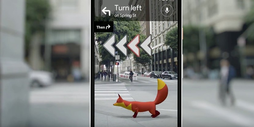
Today, the quiddity of what can be called a „digital place“ is interpreted by distributed software applications. This locational and situational understanding arises from how smart devices, above all smartphones, see the world based on their sensory perception. It corresponds to the classical understanding of place that was already described in 1977 by the influential geographer, Yi-Fu Tuan, who argued, “place is pause; each pause in movement makes it possible for location to be transformed into place.“ According to this, space allows movement, while meaning is given to places by resting, stopping and movement dropping off. This kind of understanding of place has become the focus of geomedia studies through the observation and description of mobile digital media practices, with the help of Augmented Reality, among other aids.
In die Höhe: Augmented Reality Navigation
Vortrag von Tristan Thielmann auf der Tagung „Mit weit geschlossenen Augen. Virtuelle Realitäten entwerfen“ am 31. Mai und 1. Juni 2017 an der Köln International School of Design
Das Versprechen der Augmented Reality (AR) besteht in einer immersiven Bildlichkeit mit weit geöffneten Augen – einer Erweiterung situierter Bilder in die Tiefe des Raumes. Doch diese „Tiefe“ kann je nach Blickrichtung eine ganz unterschiedliche Dimension einnehmen.
In diesem Beitrag geht es um die Sichtbarmachung des für das menschliche Auge nicht Sichtbaren aus der Höhe und in die Höhe – eine Augmentierung, die durch den Blick vom Himmel auf die Erde und umgekehrt hergestellt wird.
Linked Photography
A Praxeological Analysis of Augmented Reality Navigation in the Early Twentieth Century
Although augmented reality navigation appears at first glance to be something completely new, it is in fact based on a very old cultural technique. Virtual travel through pre-recorded spaces can be traced back at least to 1905, which saw the first attempt at capturing the residential streets of select routes in photographs. The idea was to make them available as ‘photo-auto guides,’ with superimposed textual and pictographic route instructions.
Digital Deambulation: Drone Media, Maps 4.0, and other Fabrics of Contemporary Locative Media Practices
Session, Annual Meeting of the Association of American Geographers, San Francisco, 30. März 2016
If the basis of all knowing and mapping lies in bodily movement, are we currently in the process of moving toward a deambulated essentialism that could be termed a “navigational turn” in cultural and social science?
Mapping Maps: What’s new about Neocartography?
Conference of the Research Project „Media Geography“, 20-21 January 2011, Am Eichenhang 50, D-57076 Siegen, Germany
This conference aims to bring together proposals, critique and implementations of the topics of Neocartography and Neogeography which have recently emerged and are currently being actively debated.